   
Newsletter of the IFLA Section of
Geography and Map Libraries (On-line)
Newsletter 42
June 1999
Revision of the ISBD(CM):
International Standard Bibliographic Description for Cartographic Materials
The Revision committee met in Paris at the Bibliothèque Nationale de France, Rue Richelieu, on Friday, December 11: Göran Bäärnhielm, The Royal Library, Stockholm, Henrik Dupont, The Royal Library, Copenhagen, Lothar & Gudrun Zögner, Staatsbibliothek zu Berlin, Pierre-Yves Duchemin, Olivier Loiseaux and Evelyne Henaff-Bargot, Bibliothèque Nationale de France.
Göran Bäärnhielm had prepared a number of discussion points and proposals after consultation with Sten Hedberg, Uppsala University Library, Jan Smits, Koninklijke Bibliotheek, and Francis Herbert of the Royal Geographical Society.
Discussion continued all day and resulted in a commission for Göran Bäärnhielm to produce a full revised version of the ISBD(CM) intended as a discussion material for the next IFLA conference
There were two lines regarding the structure and contents of Area 3 (Medium-Specific = Mathematical Data / Electronic Resource Characteristics) and Area 5 (Physical Description). Göran Bäärnhielm and Sten Hedberg had thought of a variant rather close to the ISBD(ER), where Area 3 would contain both mathematical data and resource characteristics, while Area 5 would be used only for local access, but be absent for remote access resources, i.e. Internet atlases etc. But most speakers in the discussion voted for the other alternative, more in line with the present structure of the ISBD(CM), where Area 3 is for mathematical data only, while Area 5 would contain the physical description of the carrier and also the technical description of the resource, for both local and remote access resources.
The discussion paper is now ready and available in Acrobat format (PDF) at the IFLANET website:
You will have to install the Acrobat Reader first, but this is available for free from the Adobe website
The paper contains the full text of the ISBD(CM) with two variants of Areas 3 and 5. There are other additions and corrections also, and a small number of examples.
All interested parties are encouraged to read the paper and express their opinion to the editor, who is also the editor of this Newsletter.
After the meeting, Monique Pelletier, Head of the Département des Cartes et Plans, and Olivier Loiseaux, guided us through the great exhibition Couleurs de la Terre on the theme of colour in cartography, including the Catalan Atlas 'live', the Green Globe and other treasures of cartography. This is part of a project Ciel et Terre, with marvellous catalogues and a web exhibition:
http://www.bnf.fr/web-bnf/expos/ciel/terre/index.htm
We could also visit the corresponding 'Heaven' exhibition in the new grand library at Tolbiac, with celestial charts and a beautiful video on the recently restored giant Coronelli globes.
65th IFLA General Conference, Bangkok 1999
Extracts from the schedule for the Geography and Maps Section according to the IFLANET website and the latest information from the Chairman.
Special Geo & Maps arrangements are marked with an *asterisk.
IFLA Express No 10, dated Januari 1999, arrived to the editor late May, but contains nothing with reference to the Geo & Maps Section.
Friday, 20 August
- 14:00-18:00
- 3. Special Libraries Coordinating Board I
Saturday, 21 August
- 09:00-11:50
- 18. Geography and Map Libraries Standing Committee I
Voting for new Section officers.
- 17:30-18:30
- Caucuses
- 19:00
- 66. Reception for IFLA Officers (on invitation only) OFF-SITE
Sunday, 22 August
- 10:30-12:00
- 74. Internet Discussion Group
- 16:30
- 78. Opening of Exhibition/ Reception
Monday, 23 August
- 10:30-11:50
- 91. Genealogy and Local History Discussion Group
Theme: "Working at the Grassroots: Helping Patrons to Find their Progenitors and to Uncover the History that They Made"
- 12:00-14:25
- 94. Geography and Map Libraries
- Genealogical geography: place identification in the map library
WILLIAM H. LAMBLE (Perth, Western Australia)
- How to put your maps on the Internet
DAVID LEHLING ALLEN (State University of New York at Stony Brook, Stony Brook, New York, USA)
- (Title to be announced)
PATRICK MCGLAMERY (University of Connecticut, Storrs, Connecticut, USA)
- (Title to be announced)
- 16:00-18:00
- 98. Opening Session (must be seated by 15:30)
- 99. Plenary Session
- 19:30-23:30
- 100. Gala Reception/Dinner and Cultural Performance
Tuesday 24 August
- Morning.
- *Visit to the Royal Thai Survey.
- Evening
- 125. Library Receptions
Wednesday 25 August
- *Field trip down the Malay Peninsula to Prachuap Khiri Khan, at Thailand's narrowest border.
Thursday 26 August
- *GIS Workshop at the Chulalongkorn University. Convener: Patrick McGlamery (planned).
Friday, 27 August
- 10:30-12:20
- 198. Geography and Map Libraries Standing Committee II
- 12:30-14:25
- 210. Special Libraries Coordinating Board II
- 15:00-18:00
- 218. Council II and Closing Session
- IFLA Express No 1, dated Januari 1999, arrived to the editor in late May, but contained no information regarding the Geo & Maps Section.
Nominations to the Standing Committee
David McQuillan and Göran Bäärnhielm have completed their 2nd term by 1999.
Carmen Liter Mayayo, Spain, Olivier Loiseaux and Pierre Planques, France, have completed their 1st term 1995-1999 and may continue.
Natalia Kotelnikova, Russia, Patrick McGlamery, USA (for the American Library Association) and Lothar Zögner, Germany, are continuing the 1997-2001 term.
Christopher Baruth has been nominated by the Special Libraries Association, USA, for the 1999-2003 term.
Anita Oser will technically fill the other SLA slot, but be listed as observer until the 2001-2005 term.
Melissa Lamont will fill the 1999-2003 American Library Association slot.
Corresponding members: Nancy Machado Lorenzo, Biblioteca Nacional José Marti, Havana, Cuba.
Observers: A.M. Cassassas Ymbert, Barcelona, Pierre-Yves Duchemin, Paris, Lorraine Dubreuil, Montreal, Egon Klemp, Berlin, Jan Smits, The Hague, Franz Wawrik, Wien.
Special adviser: Gary North, USGS; Reston, Virginia.
Appendix : Geospatial data archiving
The ITC case
Presented on 18 August 1998
For the IFLA conference visitors
By
Drs. J.P.G. Bakx (Wan)
M.Sc. Physical Geography and Cartography
Lecturer in Remote Sensing and Geoinformatics
ITC
Introduction
The major objective of the presentation is to give a limited overview of initiatives to archive Geospatial data and its related META data abroad and in the Netherlands followed by a presentation of what data is available at the ITC and what initiatives exist within the ITC premises.
Context
First of all archiving is defined as "to store for retrieval such that others do NOT make or do the same for the same purpose. In this context it should be noted that in science it is sometimes necessary to repeat data acquisition or processing. Archiving of alphanumeric data is well established and Libraries around the world have impressive networks to enable the retrieval of data for anyone interested. Geospatial data has only recently become a hype to have and share. The WWW and all its pressure on the world to share and transfer data has a major influence in that hype.
As with archiving alphanumeric data, archiving geospatial data has two aspects; the data itself (in many different forms, formats, structures. . . ) and the data required to be able to retrieve the geospatial data, often referred to as META-data. Secondly you can question if all geospatial data should be directly available in a shareable environment and if the interface should be contain only predefined queries or gives the user the possibility to search and analyse the META data for his/her own purpose. The first interface leads usually to very user-friendly systems but restricts the user in querying the META-data in unexpected ways.
Geospatial data standards initiatives
International as well as National initiatives have been taken to define standards for META-data on geospatial data. On International level the Federal Geographic Data Committee (FGDC) in the USA works on a standard and has developed a protocol to disclose georeferenced and time referenced GIS, elevation and Map data. On the other side of the ocean, CEO established CIP a search engine to search various space agencies archives. A new initiative by CEOS tries to align the two protocols such that simultaneously you get information of the whereabouts of GIS, Elevation, Map as well as Space Imagery.
ITC
At ITC students and staff are continuously busy with spatial data, often acquired by spaceborn or airborn sensors. Besides a considerable amount of data stored and archived in various places there remains an unknown amount of spatial data hidden in staff members offices, cabinets and . . . . minds. Scientist in general, ITC staff members in general are actually selfish people not eager to share their information with others (being afraid that others might do better). The archives that have been established within ITC are:
- Library
- Analogue maps (approx. 5000 entries), books, reports, project files (approx. 32000 entries)
- Photolab
- Analogue aerial photographs, aerial films (approx. 250000 entries, single AP's)
- RSG Lab
- Digital Satellite imagery (approx. 2000 entries)
A uniform policy to archive data in general and spatial data in particular does not exist in ITC. The three archives, excluding the individual archives of staff members, are not linked. The META data for the spatial data, mainly archived by the photolab and the RSG Lab is not complete.
Examples
Examples of spatial data and products at ITC are:
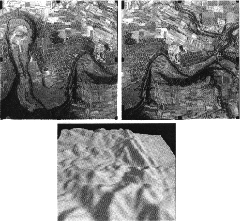
Click here to view image 233KB
Above: Thematic Mapper Satellite Image from Enschede (April 1992)
Below: Stereopair Aerial Photographs and derived Digital Elevation Model
Click here to view image 194KB
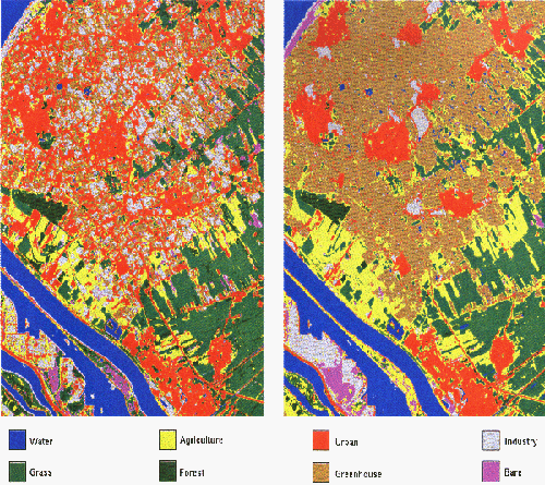
Click here to view image 189KB
Above: Automatic Classification of Landuse/Landcover (left), improvement of the result by using existing knowledge/data about spatial structures.
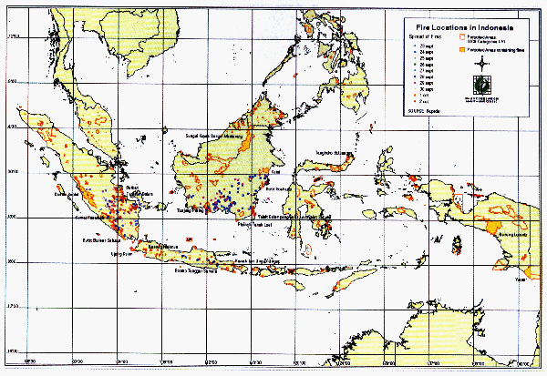
Below: Old satellite image (reference), new satellite image and derived map showing Forest Fires in Indonesia.
Click here to view image 111KB
Click here to view image 80KB
Monitoring, being one of the possible applications of spatial data acquired from space and/or air, requires multi temporal data. The same accounts for retrospective projects. Both require in turn an archiving system in which searches are enabled for specific data, areas etc. The reality though is that very frequently the latest of the greatest is being used; new sensor systems provide new opportunities and are tested and evaluated immediately. Contributing to this tendency to acquire new in stead of checking if old data would suffice, is the fact that even with 250000 entries in the Aerial Photograph database and 2000 entries in the Satellite Imagery database these still would cover tiny little areas on the world sphere. And since ITC's area of interest is the world, Murphy's law is often applicable.
The Satellite Image archive has been made available on the ITC fileserver as a MS ACCESS database. No special GUI has been developed, nor a specific set of SQL queries to support the access and retrieval of META data by any staff member or student of ITC. Field entries are not standardised and/or not complete. E.g. no internationally recognised list of topographical is used for the area descriptor.
Conclusion
ITC would definitely gain something from a uniform policy for archiving spatial data, including referencing to derived products, articles, source data etc. The question is however how much effort would have to be put in to accomplish the ideal situation, keeping in mind that the usage of the archiving system is expected to be rather minimal and the rather selfish attitude of scientists. Two Divisions of ITC share at least the intention to develop a curriculum on the topic such that in the framework of individual final projects or thesis projects students can develop the necessary archiving system.
This Newsletter No 42 has been issued in a printed version without illustrations and an IFLANET version with illustrations in colour (with a link from the Geo & Maps Publications page: http://archive.ifla.org/VII/s6/sgml.htm#3) The editor's limited resources for printing illustrations in any quantity is the only reason for this.
Readers without Internet access are invited to order an illustrated copy from the editor.
June 3, 1999
Göran Bäärnhielm
The Royal Library - National Library of Sweden
PO Box 5039
SE-102 41 Stockholm
Sweden
Tel.: +46-8-463 4180
Fax: +46-8-463 4328
E-mail: goran.baarnhielm@kb.se
|